Context and Background
Planning background
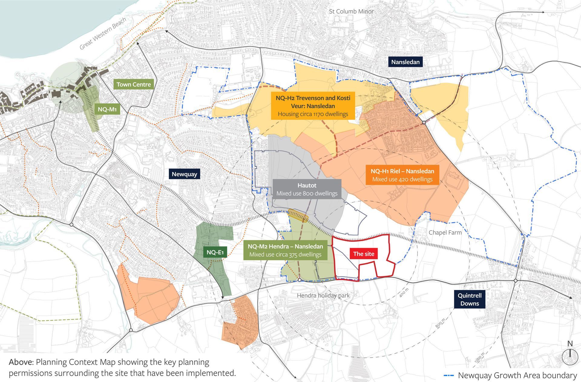
The whole site falls within the Newquay Growth Area (as illustrated below) and is identified as ‘Long Term Strategic Reserve Land,’ as shown in the illustrative masterplan (HP/5322/SK235) approved under the adopted LDO (PA20/08661).
Need for housing
- Significant Cornwall-wide housing need driven by large increase in housing requirement following changes to national planning policy
- Cornwall can no longer demonstrate a five-year housing land supply and therefore sustainable and well-connected sites are required now to help reduce the shortfall.
- The clear need for additional housing will potentially be exacerbated by the fact that the adjacent site (Hendra, NQ-H2) is only expected to deliver 150 homes of the wider allocation which requires the delivery of 375 homes. This would leave a shortfall of 225 homes to be delivered within the Newquay Growth Area.
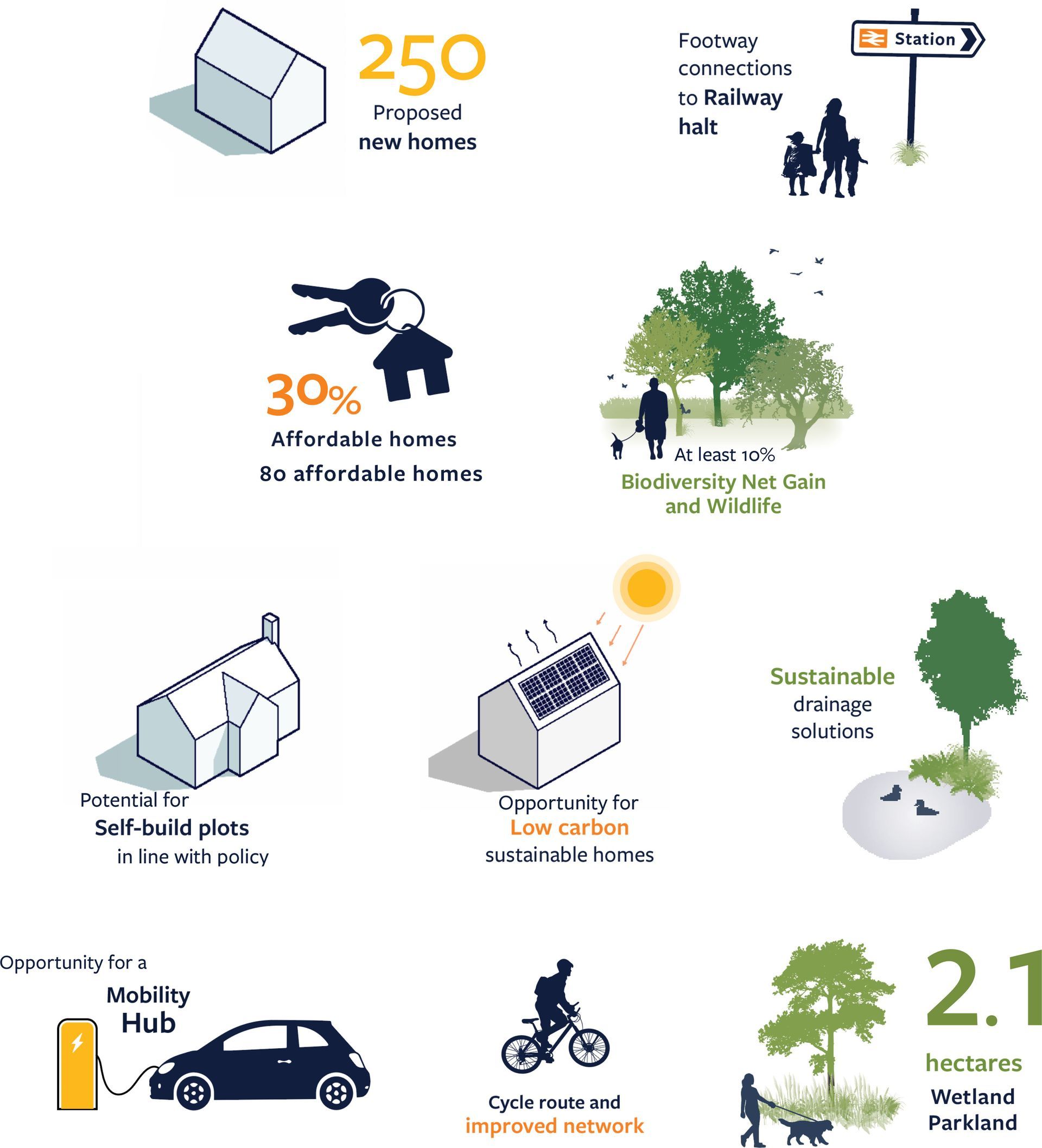
- Latest information on local, affordable, housing need confirms that there are 929 households on the Homechoice Register who have specified a need for affordable housing in Newquay, and 85 households in Colan parish.
Existing planning allocations
There are 3 sites allocated in the Cornwall Site Allocation Development Plan Document (DPD) (Adopted November 2019) at Nansledan:
NQ-H1 Riel – Nansledan
Mixed use site comprising approximately 420 dwellings and part of Newquay Strategic Route
NQ-H2 Trevenson and Kosti Veur: Nansledan
Housing site comprising approximately 1170 dwellings and part of the Newquay Strategic Route
NQ-M2 Hendra – Nansledan
Mixed use site comprising approximately 375 dwellings; approximately 2,600 sqm B1 a/b office space and approximately 6,000 sqm B1c, B2 and B8 employment uses; Potential rail halt; Park & Ride; Household waste recycling facility; and part of the Newquay Strategic Route
The Opportunity
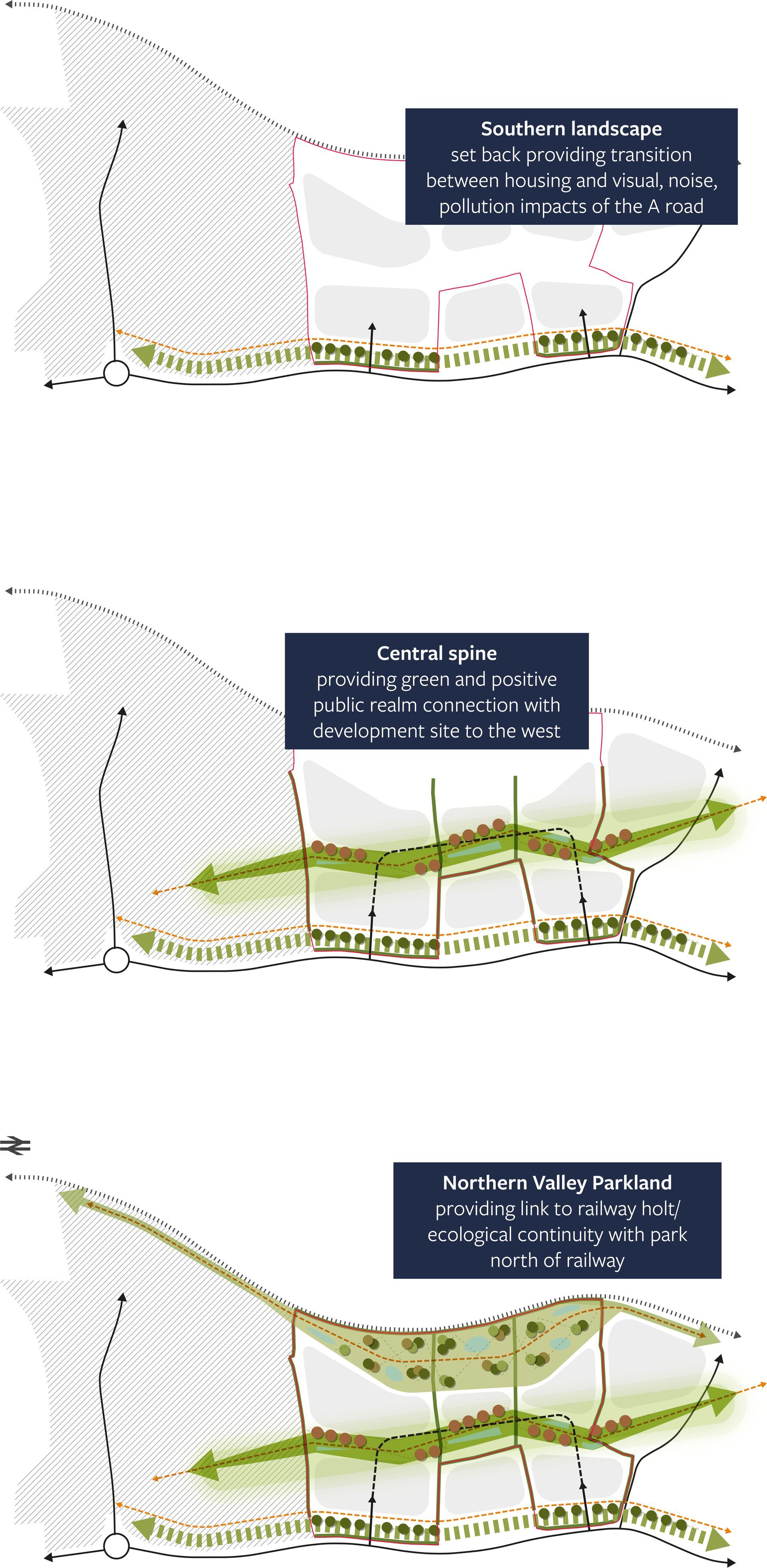
The site provides an excellent opportunity to deliver an attractive, high quality and sustainable development, to form a key part of the wider Newquay Grow Area proposals.
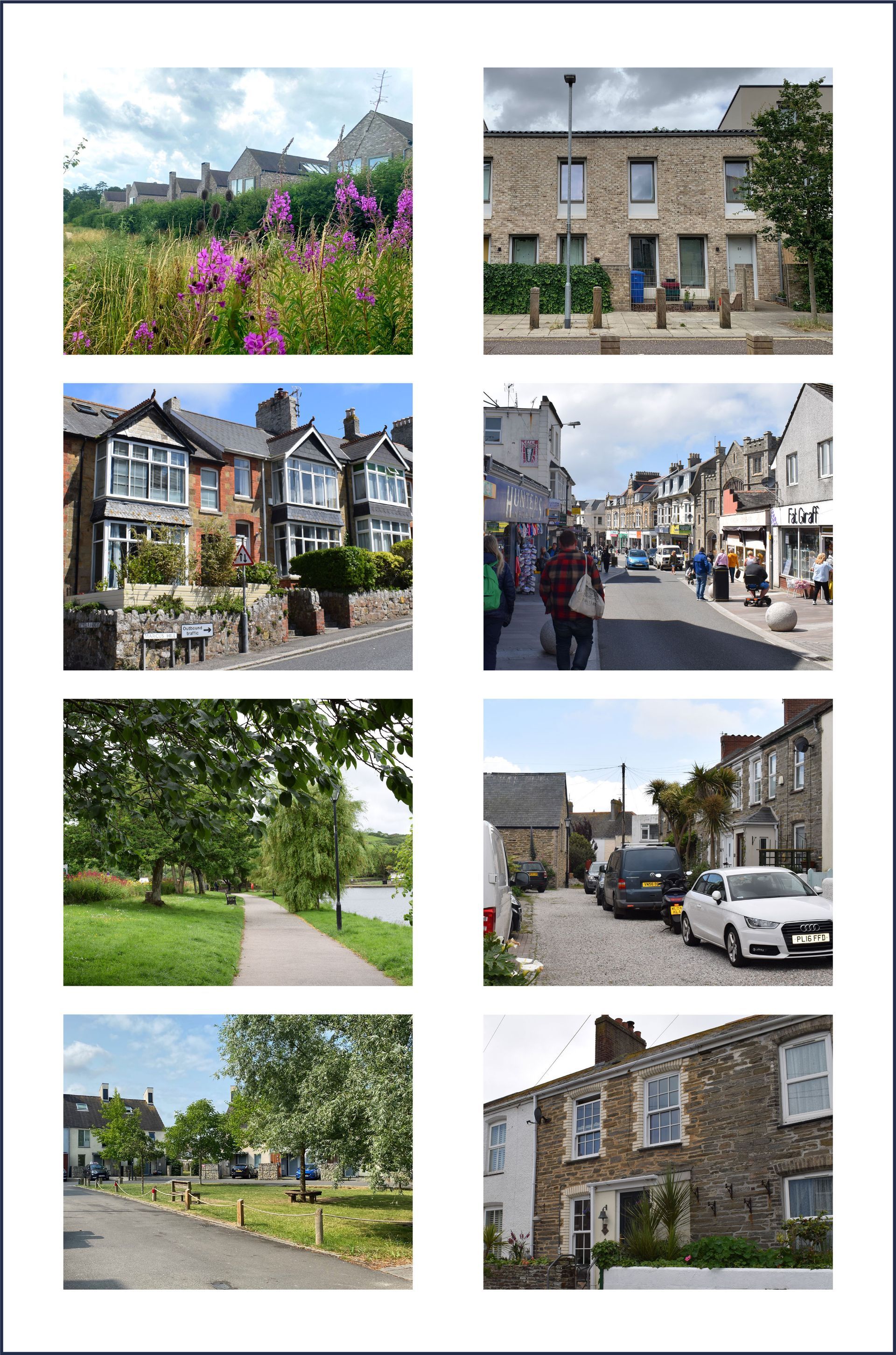
As the illustrative proposals demonstrate, the site has the opportunity to include network of attractive green spaces and places framed by beautiful and sustainable homes. New housing developed on this site can be very well connected to the wider Nansledan neighbourhood providing a strong sense of community with a balanced mix of housing types and access to a variety of services and facilities nearby.
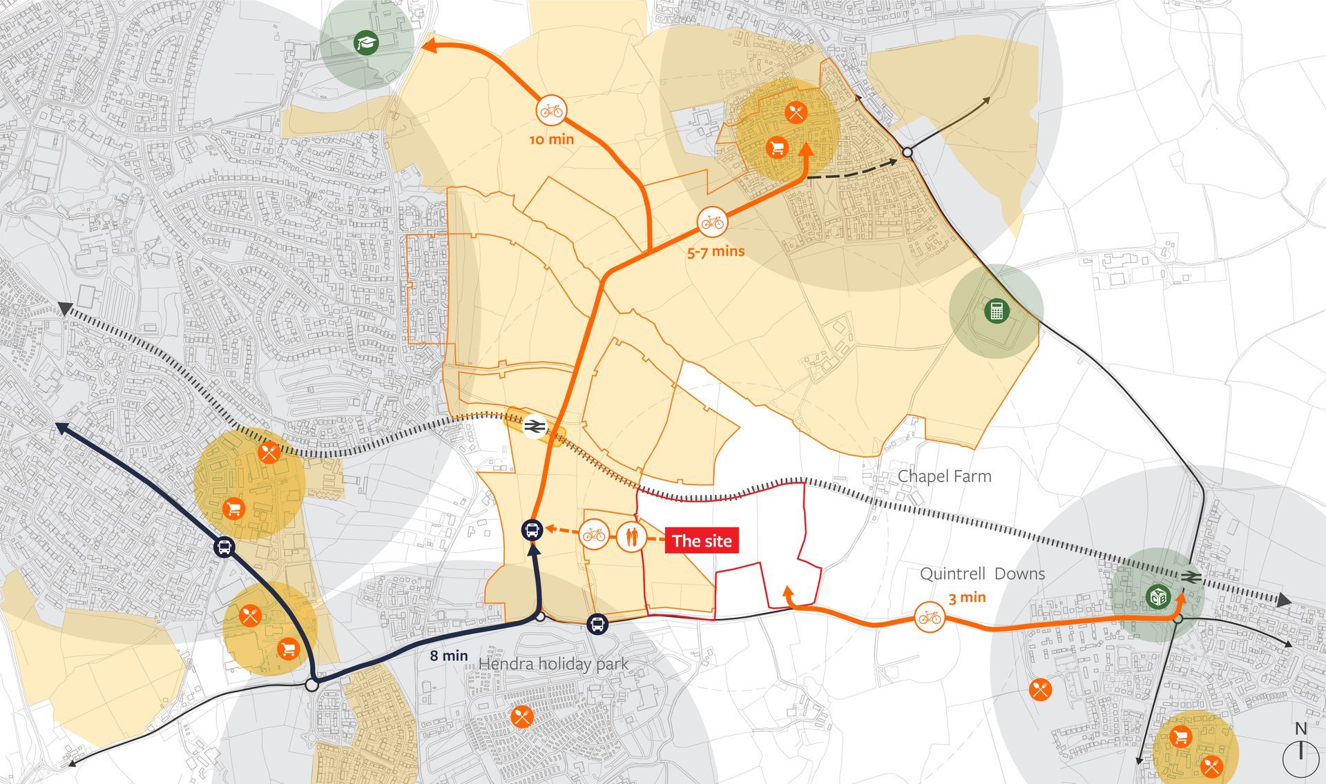
The A392 borders the southern extent of the site, providing a route into Newquay to the west via Treloggan Road. To the east, the A392 provides a key connection to the A39, providing a north-west link to Bude and North Devon, and onward connections to the A30 linking Cornwall with the regional and national road network via the M5 motorway. The centre of the site is located approximately 440 metres from the closest bus stops outside of Hendra Holiday Park which provide services to Newquay and St Austell and is approximately 1.2km from Quintrell Railway Station which provides connections into Newquay town centre and the wider Cornwall area.
Key considerations
- Strategic access connections
- Existing communities
- Neighbouring local centres
- Local education
- New strategic routes and a potential new station facility
- Part of the wider Newquay Growth Area
- Sustainable connectivity
The Site
In order to inform our understanding of the site and its surroundings, a series of technical studies have been undertaken.
Whilst a number of studies have been undertaken across the area, there are very few technical constraints associated with the site itself. The diagrams opposite and accompanying information below, provides a general summary of some of the key considerations that have been taken into account when developing the proposals. Surveys and further reporting are on-going, final reports and findings will be submitted alongside the Outline Planning Application.
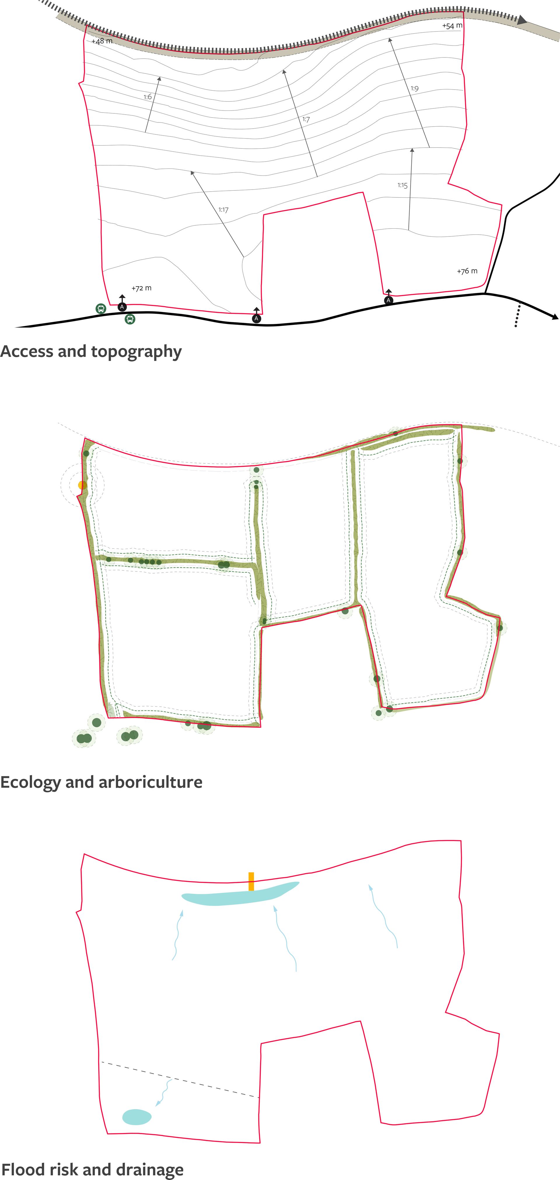
Access: There are 3 existing field gates on the southern boundary of the site.The western most provides vehicle access to the regular car boot sale which operates in the western field. The site benefits from being located within an easy walking or cycling distance from Quintrell Down Station, which is approximately 1.2km from the site. On the southern side of the A392, there is an existing shared foot / cycleway. The existing bus stops closest to the site are located on the A392, outside of Hendra Holiday Park, approximately 440 metres to the west from the centre of the site. The Newquay to St Austell railway line runs along the northern boundary. The Newquay Strategic Route (NSR) has now opened and is part of the Nansledan LDO which provides local highway improvements by creating a new link over the railway and improved connections to the Nansledan development area.
Site topography: The site is north facing and generally falls from the south to the north at varying gradients. It is generally flat towards the south with a plateau that meets the A392. The gradients vary from approx. 1:17 to 1:15 through the middle of the site. The northern areas steepen to gradients around 1:9 to 1:6 before meeting the railway line.
Ecology and Arboriculture: The majority of the site comprises arable land with a single improved grassland field to the southwest of the site which is maintained at a short sward. Given their limited structural and floral diversity, these habitats they are considered to be of low ecological value.
The fields are divided up by a network of species-poor hedgerows. Only a small number of trees are present on site, all of which are considered to be of low arboricultural and landscape value.
Flood risk and drainage: According to the Environment Agency Flood Map for Planning, the site is entirely located in Flood Zone 1, which indicates a low risk of flooding from rivers and the sea. The Risk of Flooding from Surface Water map shows that the site is not at risk of flooding from this source. Surface water runoff from the development will be managed using Sustainable Drainage Systems (SuDS). Ground conditions indicate that infiltration as a means of surface water management may be feasible.
Heritage: The Site contains no designated heritage assets and no known non-designated heritage assets. There are a number of Grade II listed buildings within the wider vicinity of the site, the closest is Gusti Vean Farmhouse and cottages which are Grade II listed.
Landscape and visual appraisal (LVIA): The site does not lie within, nor is it within the setting of, a nationally designated landscape which seeks to conserve and enhance natural beauty (e.g. Area of Outstanding Natural Beauty (AONB) or National Park). There are two local landscape designations (Areas of Great Landscape Value (AGLV)) within 5km of the site. These are the Perranporth and Holywell AGLV (located to the west) and the Watergate and Lanhern AGLV (located to the north).
Site dimensions: The site is approximately 11.6 ha and comprises four agricultural fields which slope downwards from south to north. A series of hedgerows and trees define the field boundaries.
Vision and Approach
The vision will be to design a green and sustainable neighbourhood at the entrance to Newquay, that maximises the accessibility and connectivity offered by the site’s location and nearby transport options.
The site North of the A392 provides the opportunity for:
- Potential for connections to the Newquay Town Centre, and Quintrell Down train station providing wider connectivity;
- In a position to deliver sustainable travel options due to location and development connectivity potential;
- Within an area of landscape where development can be sensitively planned and contained;
- Potential for enhanced green infrastructure connections and Public Open Space (POS)
- Vehicular access from primary route to Newquay;
- Free from flood risk or drainage issues, with the potential for inclusive Sustainable Urban Drainage (SUDs) solutions; and
- A portion of the site forms part of Newquay’s ‘Long Term Strategic Reserve Land, and borders the NQ - M2 planning allocation.